Welcome Geocachers!

I decided to start this blog to help new geocachers with some of the confusing aspects of geocaching and the website, geocaching.com.

Wednesday, December 29, 2010

Cemetery Caches

My favorite kind of caches are cemetery caches. I find cemeteries very peaceful and interesting. I especially like old cemeteries and I enjoy looking at the headstones and markers. I discovered that some cemeteries have mainly flat markers and most older ones have headstones. I have come across several interesting headstones in my travels. 
As for caches, all that I have found were hidden respectfully at the edge of the cemetery or in trees or bushes within the grounds. In Twinsburg we have two great cemeteries, one loaded with seven caches. Crown Hill Cemetery is located on Darrow Road (Rt. 91) just south of the 480. This cemetery has large grounds and a few ponds. Locust Hill Cemetery is located off of Aurora Road (Rt. 82) just north of the 480. Locust Hill is a small cemetery but it is the final resting place for notable families from Twinsburg's past. The Wilcox Twins (Twinsburg's namesakes,) Chamberlin and Bissell families have several markers. 
When I travel I really enjoy exploring new areas and the cemeteries I come across while geocaching often give me some history of the location.
A cast iron headstone.
Location: Noblesville, IN

An interesting headstone from 1907. There is a photo inlaid into it.
Location: Houston, FL

Detail of the inlaid photo.
Location: Houston, FL

An ornate headstone.
Location: Indianapolis, IN

A rather foreboding message.
Location: Delphos, OH 

This is how I would like to be buried...with a huge tree on top of me.
Location: Noblesville, IN

Saturday, November 6, 2010

Travel Bugs and Geocoins

Another fun aspect of geocaching is finding travel bugs and geocoins. These items are known as trackables and are intednded to travel from cache to cache. It is up to us to help them move around complete their missions. Unlike trading for SWAG, you do not have to leave anything in the cache when you take a trackable. 
A travel bug (TB) is basically a dog tag like item with a tracking number etched in it. Often a TB is attached to some sort of "token" like a toy car, a small doll, key chain, or just about anything. Often TB's have a misson. The TB in the photo has a mission to find other TB's from the same animated series. 
The travel bug is technically the metal dog tag on the right. I removed the tracking number.
Geocoins are the same basic idea, but they are not attached to anything. As with TB's, geocoins have a tracking number etched into them. Many geocoins have some sort of theme and can sometimes be customized. 
Front of a geocoin. I removed the tracking number
The back of the above geocoin
What seems to be the most confusing thing for cachers is how to accurately log trackables. I'll try to lay this out in a very basic way:

  1. Take the TB from the cache.
  2. Go to Geocaching.com and click "Trackables" on the left.
  3. In the "Enter the Tracking Code of the Item:" area, input the TB/geocoin tracking number and click "Track"
  4. In the upper right of the screen, click: "Found it? Log it!" 
  5. Select the type of log. If the person before you did this right, you should be able to select that you retrieved it from the cache it was in. 
  6. Input the tracking number again.
  7. Add a comment.
  8. Click "Submit Log Entry"

Now the TB/geocoin will be in your inventory. If you go to your profile, you will see all of the trackables listed in the lower right side. 

  1. Once you decide to place the trackable in another cache, you will need to log that you did so. This will allow the next person to "retrieve it" and keep the process going. 
  2. Place the trackable in a cache.
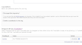
  3. Go to geocaching.com and log the cache like you normally would.
  4. BEFORE SUBMITTING THE LOG, scroll down and find the trackable you dropped off.
  5. To the right, select "Dropped Off" and then submit the log. 

Great job!

Wednesday, October 13, 2010

Watch out!

Geocaching is fun. We get out of the house, we hike around, maybe find new areas we never knew where there and have a good time. However, there are some potential hazards we should be aware of. Of course different parts of the country will have different things to watch out for, but in general many of the topics I will discuss apply across the board. Most of this information is common sense, but it is easy to overlook things we might not be familiar with. 
Keep in mind that at some point you will probably venture into the "wilderness" to look for a cache. In NE Ohio we have large (and small) areas of trees and plants that we usually refer to as "woods." Other similar areas are deserts, forests, jungles, etc. 


  •  Poisonous Plants: We have A LOT of poison ivy here in the Midwest. I didn't realize the the seriousness of poison ivy until my youngest son got into some...while geocaching. He was out of school for a week. Simply using the "leaves of three, let it be." is not enough. There are several plants with three leaves that are non toxic and some like poison sumac has 7 to 13 leaves on a branch. Thorns are another hazard to be aware of. I have found myself trapped in a forest of thorn bushes and exited with battle wounds.

Poison Ivy
Poison Ivy


  • Dangerous creatures: This group includes insects and parasites as well as animals and humans. As always, while in the wilderness, watch for creatures like snakes, skunks, ticks, mosquitoes, scorpions, spiders and hunters. I have been out caching and come across hunters placing their tree blinds. 

  • Dangerous landscapes: While geocaching it is common to pay more attention to your GPS than where you are walking. It is easy to step into a hole or trip over a log or rock, slide down a slope or (gasp!) walk off of a cliff.

  • Trespassing: Geocache owners are supposed to get permission from the property owner before hiding a cache on private property. However, caches may be hidden in a area that abuts private property and you may accidentally trespass. I like to scout out an area  using either Google maps or the geocaching website (which uses Google maps) before going out.

  • Stranger danger: You may be venturing into unfamiliar areas so it's not a bad idea for bring a friend while geocaching. There are some areas where walking around with high tech equipment just isn't a good idea. The buddy system is also a good idea when hiking in case someone gets hurt.

If you cache while traveling, be sure to know a little about the hazards for the area you will be searching. I was working in southern Tennessee and found a nice, big tick on my sock after I returned to the hotel. A full body check was in order after that discovery.
So go out there and have fun, but use common sense, be prepared and educate yourself.

Thursday, September 23, 2010

Out and About

We have made it to the cache hiding area, known as ground zero or GZ. Our GPS shows that we are right on top of the cache...but where is it? Well, that is the second part of geocaching. 
Once you have made it to the hide area, you have to locate the cache. It is very helpful to know the size of container while looking. The size will have an effect on where the cache is hidden and I have seen many different sizes and types of cache containers. Caches can be hidden just about anywhere, but there are some rules:

  • No cache can be intentionally buried underground. 
  • Most cache owners try to avoid hiding caches in a way that would cause people to destroy or dismantle anything. It is a general rule that we should leave the area better than we found it (well, at least not worse.)
  • Any cache hidden on private property should have permission form the property owner.

So you have found the cache, now what? You will want to find the log and sign it. The log is your proof that you indeed found the cache. I have read about some cache owners who will check the log in the cache against the log on the website. I personally don't bother as I figure people are only cheating themselves if they don't actually find the cache. You may then want to look in the container to see if there is anything worth trading. Once finished with the cache, be sure to replace it as you found it (unless you found it laying out in the open,) to be ready for the next cacher. Now on to the next hide!

Friday, September 10, 2010

What to Bring While Geocaching

Alright, we know what geocaching is all about...check, we have some caches in mind that we are interesting in locating...check, we have the cache information either written down or saved to our GPS...check. Let's go!! 
WAIT! Besides your GPS, what should you take with you? The answer will vary depending on who you talk to. I'll go over what I carry in my geocaching backpack but of course, you may need to carry different items based on your area and how far you plan to hike. I usually search for caches that are relatively easy to hike to so I don't need a lot of survival gear but I try to follow the motto: "Be prepared."


In my geocaching pack, I have:

  • Two pens and a pad of paper. Many caches do not have a writing tool included and if they do, the pens sometimes don't work. I never have to worry about that because I always bring my own. One is a fine tip Sharpie which is nice for those damp logs. I use the paper to list the caches I find so I don't have to TRY to remember them all. This is especially helpful when finding several in a day. I usually jot down the cache number ie: GC292WG. It makes it easy to log my finds that way.
  • A large trash bag, a small kitchen trash bag and a few grocery and zip-lock bags. Besides the obvious use of removing trash you may find (cache in, trash out or CITO) I have used these bags to cover my muddy feet when I get back to the car. If necessary I could convert the large bag into a rain poncho. If my clothes get really muddy, I could use the bags to hold them while I drive home. 
  • My "SWAG bag" of stuff I can trade if I find anything interesting in a cache. My youngest son donates toys he doesn't want anymore.
  • A small first aid kit. I have fallen or gotten scraped many times. It's handy to have some antiseptic wipes and bandages if needed.
  • I have a standard compass that I use often. Even with the technology at hand, when you are standing on the middle of the woods, it is nice to be able to find out which way north is at a glance. Plus, if anything happened to my GPS, I have the compass to help me get out.
  • Bug spray.
  • Extra batteries for my GPS.
  • Rubber cement for spot repairs. Water is the enemy of caches.
  • A clean old sock. Why? I don't know but I'm sure I'll be glad if/when I need it.
  • Extra blank log sheets. Sometimes you'll find a cache and the log is full. Instead of complaining about it I add a new sheet.
  • Pre-made micro caches. If I come across a place that could use a cache, I have one with me. No need to make return visits, I can place the container, take the coordinate readings and submit for a new cache.
  • A small stapler.
  • A small measuring tape. Very handy when scouting areas for hiding new caches.
  • A headlamp. It's nice to go hands free in dark areas or at night.
  • A folding knife.
  • I got a good idea from a local fellow cacher (JesterJack) to get a telescoping small mirror. This is handy when looking in blind spots. It sure is sketchy reaching blindly into or around some places in search of the cache. I think you can find these at auto parts stores. I saw one recently, but the mirror was bigger than I wanted.

Of course, if you plan to take an extensive hike, you may want to bring water, food, warm clothing, a fire starting kit etc. Common sense stuff really.
Now let's go find some caches.

Wednesday, September 8, 2010

Paperless Caching and Creating "Pocket Queries"

The method I mentioned in my previous post requires you to plan your caching adventure in advance. If you want to have the detailed information about the caches you are hunting, you will need to write it down or print it.  
What if you are out on errands and you decide you want to see if any caches are nearby? Then paperless caching is the thing for you! One big difference between the "Send to my GPS" and paperless caching using pocket queries is that with the latter, information about the cache, i.e. cache description, hint, previous logs, is saved to the GPS. When you use the "Send to my GPS" option, only the coordinate information goes to the GPS. 
In order to create pocket queries, you must become a premium member. A word about the premium membership that is available on geocaching.com: The basic membership, although necessary to use geocaching.com, is free. The premium membership is not. I wouldn't just jump right into the premium membership. I suggest trying geocaching out for a while first. I have a few friends that found a cache or two then stopped hunting. No need for a paid membership there. I was geocaching for about a month and a half when I got my premium membership. I knew by then that I would use it. The premium membership will cost you $30 per year. 
What you receive includes the ability to create pocket queries, find caches along a route (great for road trips,) sign up for cache alerts, save .GPX files to your iPhone (and some other smart phones), manage bookmark lists and find special caches available only to premium members. I mainly use the pocket queries,routes and new cache notification features.
Pocket queries are special lists of caches in a certain area. You can customize the search to show only caches of a certain type, size or location. Geocaching.com will email a file that can be transferred to your GPS or phone. You can also have the query automatically created and emailed to you. I do this with the caches around my home coordinates. 
I probably won't go into how to get he .GPX files to your GPS unless there is a call for it. There are a few different methods available and the best one will probably depend on your GPS. Since I have two GPS receivers, I use two methods to transfer the .GPX data to them.
Waypoints: Some people are confused by the term waypoints. A waypoint is simply a location on the earth. We identify waypoint using GPS coordinates such as N°16.680, W 081° 23.234 A geocache is a waypoint, a parking area is a waypoint, your home is a waypoint. Some GPS receivers let you mark a waypoint while you are "out". This is helpful when you are hiking and want to make sure you can find your car.
Now get out there and find some caches!

Tuesday, September 7, 2010

500th Cache Found

On Labor Day 2010 I found my 500th cache. I went out with my son Cole and his friend, Angela. This cache was really cool and was a different presentation than most caches. It took me 11 months (almost to the day) and 18 states to find my 500th cache. I can't wait to get out there hunting again soon!

Sunday, August 22, 2010

Basic Equipment

In order to find geocaches, you really only need two things: a computer and something that will display your current coordinates aka a GPS. If you are reading this, you or someone you know has access to a computer. Step one, check! 
GPS technology is surprisingly all around us. Almost all current cellular phones have a GPS receiver. Look around as you are driving and you will see many motorists with GPS systems in their cars. Any device that can detect and display your position on the earth can be used for geocaching. Obviously some features will make cache selection and naviagtion easier.
If you are just starting out, I suggest getting to know your GPS and its features. Some GPS units may have hidden features that the manufacturer does not tell you. 
An example is the Garmin Nuvi series. I don't know if all Nuvi models have this little trick, but my Nuvi 205 does and I have shown this to other Nuvi users with different models. I found this while poking around online so I will not try to claim the discovery as my own. In order to see a screen that will display your current coordinates, the satellites your GPS is tracking and other info, you push the signal strength bar that is found in the 'home' screen for about 6 seconds. My Nuvi 205 home screen shows icons for "where to?" and "View Map." In the upper right-hand corner there is a display showing the strength of my GPS signal. That is where you press to find that hidden screen. 
I learned a lot by reading posts on the Groundspeak message board (http://forums.groundspeak.com/GC/)


Yes I changed the coordinates...


So you have a computer and a GPS. Now what? Now you need to get your hands on some cache coordinates. Geocaching.com may not be the only place to get cache coordinates, but it is the only one that I use. The first thing to do is to create a user account. Before you start, think of a cool user name. In fact, think of a few because chances are, your first choice will already be taken. You can add avatars to your profile and whatever additional information you wish. Once you are on the website, take a look around. There is a lot of information to be found of you take the time to look. I would check out the glossary so you can become familiar with the common terms and abbreviations. Geocaching uses a lot of abbreviations: TFTC, TFTH, TNLNSL and more!
Back to the topic. There are a few ways to get cache coordinates to your GPS, assuming it can connect to a computer. If your GPS cannot connect, simply write down the coordinates and use your GPS to guide you there. 
So let's assume you have a GPS that can connect to your computer. There are a few options available to you. First select a cache you are interested in finding. NOTE: I probably won't go into how to use geocaching.com to locate caches in your area unless people request it. Open the cache information page and take a look around. There is a lot of information to be found there including the type and size of the cache, the coordinates, a description of the cache and possibly a hint. You can look at a Google map of the area as well. In the upper area of the page you will see some options for sending the information to either your GPS or phone. Make sure your device is connected before clicking the option to send the cache info. 
What happens next will depend on the device you are sending the info to. When I started geocaching, I used this method to send the cache data to my Garmin Nuvi 205 GPS. What happens with this GPS is that the cache becomes a favorite. I don't know how other GPS's or phones will handle the info. If anyone uses this method and has insight into it, please comment. I will go into another method in my next post.

Thursday, August 19, 2010

Starting at the Beginning

Q: What is geocaching?
A: It is a type of high tech hide and seek game. People hide containers of varying sizes called caches. Caches will have at the very least, a log for the finder to sign, proving he or she found the actual cache. Bigger containers often contain small trade items, AKA SWAG. SWAG is just 'stuff' placed in a cache for trading. It can be almost anything except for inappropriate items such as alcohol, drugs, adult material explosives, weapons etc. 
The person hiding the cache notes the GPS coordinates and uploads them along with details about the cache and the area and possibly a hint to geocaching.com. The person wishing to find the cache goes to geocaching.com and gets the coordinates for the cache or caches they want to hunt. They use a GPS to get to 'ground zero' (GZ) where they now have to find the container that is most likely hidden somewhere nearby. Once the container is found, the geocacher usually signs the log to prove they found it, maybe trade some stuff then replaces the cache as it was and move on. 
At some point most cachers will log into geocaching.com and log their finds. He or she can post a note about their experience and post photos (as long as the cache's hiding place is not given away) Geocaching.com keeps track of each member's finds and displays a total find count.
There are several characteristics about geocaching that can be confusing, especially in the beginning. Some of these I will address as separate blog posts.


Areas of confusion include:
  • Do I need a special GPS to go geocaching?
  • How do I use my car GPS, phone GPS etc. to geocache?
  • How do I get the cache coordinates to my GPS?
  • Should I go ahead and pay to become a premium member?
  • What are waypoints?
  • What are trackable items (travel bugs and geocoins?)
  • What do I do with trackable items?